
 Pointe-à-la-Croix
Sainte-Irène, Quebec
Marsoui
Hecla
Muskrat Dam
Wunnummin Lake
Sainte-Brigitte-de-Laval
Drayton
Mauricie
Pointe-à-la-Croix
Sainte-Irène, Quebec
Marsoui
Hecla
Muskrat Dam
Wunnummin Lake
Sainte-Brigitte-de-Laval
Drayton
Mauricie
Camrose Ski Club on the map, Camrose, Canada
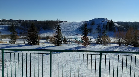
Photo
Where is located Camrose Ski Club
Camrose Ski Club — local attraction, which is located at Unnamed Road, T4V, Camrose, AB T4V 1X8, Canada and belongs to the category — ski club. Average visitor rating for this place — 4.4 (according to 8 ratings, information from open sources and relevant for 2022).
Exact location — Camrose Ski Club, marked on the map with a red marker.
You can get directions to Camrose Ski Club on the map from your location.
What else is interesting in Camrose? You can see all the sights if you go to the city page.
Coordinates
Camrose Ski Club, Canada coordinates in decimal format: latitude — 53.00484879733752, longitude — -112.83031660164941. When converted to degrees, minutes, seconds Camrose Ski Club has the following coordinates: 53°0′17.46 north latitude and -112°49′49.14 east longitude.
Nearby cities
The largest cities that are located nearby:
- Edmonton — 72 km
- Calgary — 235 km
- Saskatoon — 429 km
- Kelowna — 588 km
- Regina — 645 km
- Spokane
 (United States) — 685 km
 - Abbotsford — 816 km
- Coquitlam — 829 km
- Anmore — 831 km
- Surrey — 839 km
- Burnaby — 841 km
- Vancouver — 850 km
- Delta — 856 km
- Richmond — 858 km
- Bellevue (United States) — 920 km
- Victoria — 925 km
- Seattle (United States) — 928 km
- Tacoma (United States) — 963 km
- Boise (United States) — 1074 km
Distance to the capital
Distance to the capital (Ottawa) is about — 2791 km.