
 Pointe-à-la-Croix
Sainte-Irène, Quebec
Marsoui
Hecla
Muskrat Dam
Wunnummin Lake
Sainte-Brigitte-de-Laval
Drayton
Mauricie
Pointe-à-la-Croix
Sainte-Irène, Quebec
Marsoui
Hecla
Muskrat Dam
Wunnummin Lake
Sainte-Brigitte-de-Laval
Drayton
Mauricie
Paradise Valley Golf Course on the map, Medicine Hat, Canada
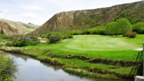
Photo
Where is located Paradise Valley Golf Course
Paradise Valley Golf Course — local attraction, which is located at 90 Gehring Rd SE, Medicine Hat, AB T1B 4W1, Canada and belongs to the category — public golf course. Average visitor rating for this place — 4.6 (according to 188 ratings, information from open sources and relevant for 2022).
Exact location — Paradise Valley Golf Course, marked on the map with a red marker.
You can get directions to Paradise Valley Golf Course on the map from your location.
What else is interesting in Medicine Hat? You can see all the sights if you go to the city page.
Coordinates
Paradise Valley Golf Course, Canada coordinates in decimal format: latitude — 50.009897110849785, longitude — -110.69516000175958. When converted to degrees, minutes, seconds Paradise Valley Golf Course has the following coordinates: 50°0′35.63 north latitude and -110°41′42.58 east longitude.
Nearby cities
The largest cities that are located nearby:
- Calgary — 261 km
- Saskatoon — 357 km
- Edmonton — 429 km
- Regina — 430 km
- Spokane
 (United States) — 567 km
 - Kelowna — 629 km
- Boise (United States) — 837 km
- Abbotsford — 851 km
- Coquitlam — 878 km
- Anmore — 882 km
- Surrey — 885 km
- Burnaby — 891 km
- Bellevue (United States) — 900 km
- Delta — 900 km
- Vancouver — 901 km
- Richmond — 906 km
- Seattle (United States) — 910 km
- Tacoma (United States) — 935 km
- Victoria — 948 km
Distance to the capital
Distance to the capital (Ottawa) is about — 2643 km.