
 Pointe-à-la-Croix
Sainte-Irène, Quebec
Marsoui
Hecla
Muskrat Dam
Wunnummin Lake
Sainte-Brigitte-de-Laval
Drayton
Mauricie
Pointe-à-la-Croix
Sainte-Irène, Quebec
Marsoui
Hecla
Muskrat Dam
Wunnummin Lake
Sainte-Brigitte-de-Laval
Drayton
Mauricie
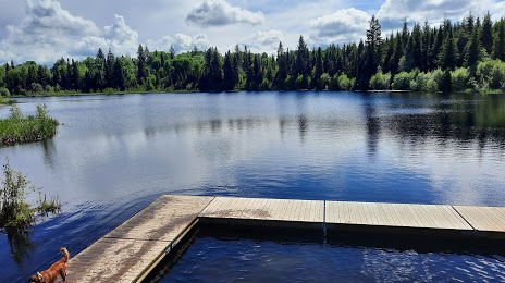
Forests for the World on the map, Prince George, Canada
Photo
Where is located Forests for the World
Forests for the World — local attraction, which is located at 53°53'42.9"N 122°49'55.4"W, Prince George, BC V2M 7C5, Canada and belongs to the category — city park. Average visitor rating for this place — 4.7 (according to 216 ratings, information from open sources and relevant for 2022).
Exact location — Forests for the World, marked on the map with a red marker.
You can get directions to Forests for the World on the map from your location.
What else is interesting in Prince George? You can see all the sights if you go to the city page.
Coordinates
Forests for the World, Canada coordinates in decimal format: latitude — 53.895708748307705, longitude — -122.83167570161581. When converted to degrees, minutes, seconds Forests for the World has the following coordinates: 53°53′44.55 north latitude and -122°49′54.03 east longitude.
Nearby cities
The largest cities that are located nearby:
- Kelowna — 502 km
- Anmore — 509 km
- Coquitlam — 512 km
- Vancouver — 513 km
- Burnaby — 514 km
- Surrey — 523 km
- Richmond — 526 km
- Delta — 533 km
- Abbotsford — 538 km
- Victoria — 609 km
- Edmonton — 610 km
- Calgary — 682 km
- Seattle
 (United States) — 698 km
 - Bellevue (United States) — 698 km
- Tacoma (United States) — 737 km
- Spokane (United States) — 797 km
- Portland (United States) — 928 km
- Salem (United States) — 992 km
- Eugene (United States) — 1091 km
Distance to the capital
Distance to the capital (Ottawa) is about — 3452 km.