
 Pointe-à-la-Croix
Sainte-Irène, Quebec
Marsoui
Hecla
Muskrat Dam
Wunnummin Lake
Sainte-Brigitte-de-Laval
Drayton
Mauricie
Pointe-à-la-Croix
Sainte-Irène, Quebec
Marsoui
Hecla
Muskrat Dam
Wunnummin Lake
Sainte-Brigitte-de-Laval
Drayton
Mauricie
Penticton Golf & Country Club on the map, Penticton, Canada
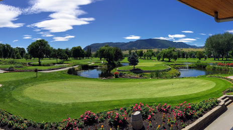
Photo
Where is located Penticton Golf & Country Club
Penticton Golf & Country Club — local attraction, which is located at 600 Comox St, Penticton, BC V2A 2C1, Canada and belongs to the category — golf club. Average visitor rating for this place — 4.4 (according to 145 ratings, information from open sources and relevant for 2022).
Exact location — Penticton Golf & Country Club, marked on the map with a red marker.
You can get directions to Penticton Golf & Country Club on the map from your location.
What else is interesting in Penticton? You can see all the sights if you go to the city page.
Coordinates
Penticton Golf & Country Club, Canada coordinates in decimal format: latitude — 49.49353174507674, longitude — -119.60890060177812. When converted to degrees, minutes, seconds Penticton Golf & Country Club has the following coordinates: 49°29′36.71 north latitude and -119°36′32.04 east longitude.
Nearby cities
The largest cities that are located nearby:
- Kelowna — 44 km
- Abbotsford — 204 km
- Coquitlam — 232 km
- Anmore — 236 km
- Surrey — 238 km
- Burnaby — 245 km
- Delta — 252 km
- Vancouver — 255 km
- Richmond — 259 km
- Spokane
 (United States) — 260 km
 - Bellevue (United States) — 285 km
- Seattle (United States) — 292 km
- Victoria — 301 km
- Tacoma (United States) — 328 km
- Calgary — 420 km
- Portland (United States) — 500 km
- Salem (United States) — 571 km
- Edmonton — 601 km
- Eugene (United States) — 663 km
Distance to the capital
Distance to the capital (Ottawa) is about — 3286 km.