
 Pointe-à-la-Croix
Sainte-Irène, Quebec
Marsoui
Hecla
Muskrat Dam
Wunnummin Lake
Sainte-Brigitte-de-Laval
Drayton
Mauricie
Pointe-à-la-Croix
Sainte-Irène, Quebec
Marsoui
Hecla
Muskrat Dam
Wunnummin Lake
Sainte-Brigitte-de-Laval
Drayton
Mauricie
Penticton Sign on the map, Penticton, Canada
Photo
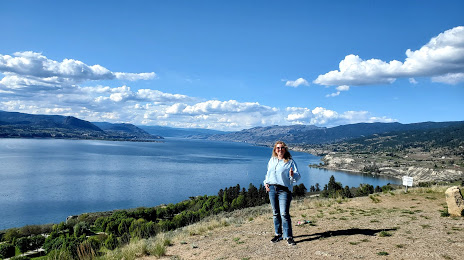
Where is located Penticton Sign
Penticton Sign — local attraction, which is located at Penticton, BC V2A 8S5, Canada and belongs to the category — historical landmark. Average visitor rating for this place — 4.6 (according to 28 ratings, information from open sources and relevant for 2022).
Exact location — Penticton Sign, marked on the map with a red marker.
You can get directions to Penticton Sign on the map from your location.
What else is interesting in Penticton? You can see all the sights if you go to the city page.
Coordinates
Penticton Sign, Canada coordinates in decimal format: latitude — 49.49496747898418, longitude — -119.56591632762738. When converted to degrees, minutes, seconds Penticton Sign has the following coordinates: 49°29′41.88 north latitude and -119°33′57.3 east longitude.
Nearby cities
The largest cities that are located nearby:
- Kelowna — 44 km
- Abbotsford — 204 km
- Coquitlam — 232 km
- Anmore — 236 km
- Surrey — 238 km
- Burnaby — 245 km
- Delta — 252 km
- Vancouver — 255 km
- Richmond — 259 km
- Spokane
 (United States) — 260 km
 - Bellevue (United States) — 285 km
- Seattle (United States) — 292 km
- Victoria — 301 km
- Tacoma (United States) — 328 km
- Calgary — 420 km
- Portland (United States) — 500 km
- Salem (United States) — 571 km
- Edmonton — 601 km
- Eugene (United States) — 663 km
Distance to the capital
Distance to the capital (Ottawa) is about — 3283 km.