
 Pointe-à-la-Croix
Sainte-Irène, Quebec
Marsoui
Hecla
Muskrat Dam
Wunnummin Lake
Sainte-Brigitte-de-Laval
Drayton
Mauricie
Pointe-à-la-Croix
Sainte-Irène, Quebec
Marsoui
Hecla
Muskrat Dam
Wunnummin Lake
Sainte-Brigitte-de-Laval
Drayton
Mauricie
Riverside Park on the map, Kamloops, Canada
Photo
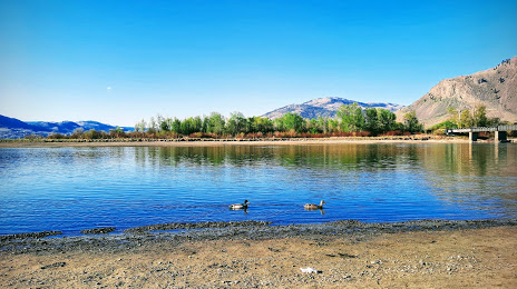
Where is located Riverside Park
Riverside Park — local attraction, which is located at 100 Lorne St, Kamloops, BC V2C 1V9, Canada and belongs to the category — city park. Average visitor rating for this place — 4.6 (according to 1882 ratings, information from open sources and relevant for 2022).
Exact location — Riverside Park, marked on the map with a red marker.
You can get directions to Riverside Park on the map from your location.
What else is interesting in Kamloops? You can see all the sights if you go to the city page.
Coordinates
Riverside Park, Canada coordinates in decimal format: latitude — 50.679415194942464, longitude — -120.33411760687738. When converted to degrees, minutes, seconds Riverside Park has the following coordinates: 50°40′45.89 north latitude and -120°20′2.82 east longitude.
Nearby cities
The largest cities that are located nearby:
- Kelowna — 105 km
- Abbotsford — 230 km
- Coquitlam — 235 km
- Anmore — 236 km
- Surrey — 246 km
- Burnaby — 246 km
- Vancouver — 254 km
- Delta — 262 km
- Richmond — 263 km
- Victoria — 334 km
- Bellevue
 (United States) — 366 km
 - Seattle (United States) — 371 km
- Spokane (United States) — 397 km
- Tacoma (United States) — 410 km
- Calgary — 437 km
- Edmonton — 550 km
- Portland (United States) — 598 km
- Salem (United States) — 668 km
- Eugene (United States) — 764 km
Distance to the capital
Distance to the capital (Ottawa) is about — 3318 km.