
 Pointe-à-la-Croix
Sainte-Irène, Quebec
Marsoui
Hecla
Muskrat Dam
Wunnummin Lake
Sainte-Brigitte-de-Laval
Drayton
Mauricie
Pointe-à-la-Croix
Sainte-Irène, Quebec
Marsoui
Hecla
Muskrat Dam
Wunnummin Lake
Sainte-Brigitte-de-Laval
Drayton
Mauricie
Manitou Islands Provincial Park on the map, North Bay, Canada
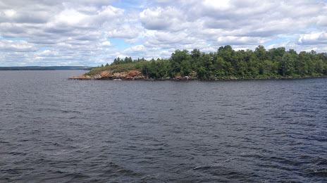
Photo
Where is located Manitou Islands Provincial Park
Manitou Islands Provincial Park — local attraction, which is located at Nipissing, Unorganized, North Part, ON, Canada and belongs to the category — state park. Average visitor rating for this place — 4.5 (according to 33 ratings, information from open sources and relevant for 2022).
Exact location — Manitou Islands Provincial Park, marked on the map with a red marker.
You can get directions to Manitou Islands Provincial Park on the map from your location.
What else is interesting in North Bay? You can see all the sights if you go to the city page.
Coordinates
Manitou Islands Provincial Park, Canada coordinates in decimal format: latitude — 46.262123090412146, longitude — -79.57456370189072. When converted to degrees, minutes, seconds Manitou Islands Provincial Park has the following coordinates: 46°15′43.64 north latitude and -79°34′28.43 east longitude.
Nearby cities
The largest cities that are located nearby:
- Barrie — 213 km
- Richmond Hill — 268 km
- Whitby — 270 km
- Oshawa — 271 km
- Markham — 271 km
- Vaughan — 273 km
- Brampton — 286 km
- Toronto — 294 km
- Mississauga — 301 km
- Gatineau — 306 km
- Guelph — 312 km
- Oakville — 315 km
- Waterloo — 326 km
- Kingston — 329 km
- Kitchener — 330 km
- Burlington — 331 km
- Cambridge — 333 km
- Hamilton — 340 km
- Saint Catharines — 349 km
Distance to the capital
Distance to the capital (Ottawa) is about — 315 km.